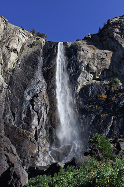
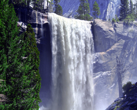
Bridal Veil Falls, Yosemite
Well, Fall quarter has come to a close, and with it my class on the geology of national parks also ends. This class has been one of my all time favorites, due in no small part to the outstanding instructor of the course, Dr. David Osleger (although he insists his students call him Dave). He's a guy you just can't help but like. His obvious enthusiasm and expertise in geology, his kind and lighthearted nature, and his unpretentious coolness made him a really fun teacher. He actually sat down next to me one day and talked with me for a few minutes about my plans for Thanksgiving, and learned my name. This is a rare occurrence in classes of 250 people, but he's just that kind of guy. All this combined with his ability to make an hour fly by in moments with his engaging and easily understood lectures really made his class a privilege to experience.
Sorry if it sounds like I have a crush on him.
Anyway, since I enjoyed the class so much, I figured I would regurgitate some of what I learned for what I hope will be an enjoyable post. I've gone back and forth about what exactly would be best to talk about, but I've decided that the best topic to cover in this format would be Yosemite National Park. It is an ideal fit for this post because it is a bit more contained and easy to understand than some of the other topics in the class, but is still complex enough to convey an element of wonder and mystery. Additionally, it is the park I've had the most personal experience with, which will allow me to convey more understanding than I might be able to otherwise. So let's get started!
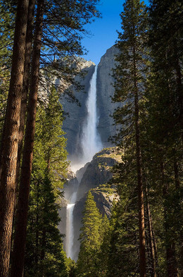
Yosemite Falls, the tallest waterfall in North America.
The Park
I'll begin by just showing some of the park's features in case anyone is unfamiliar with it. When most people think of Yosemite, they think of the valley which comprises the most popular destination within the park. In truth, it is actually more extensive than that, but for the purposes of this post I'll stick mostly to Yosemite Valley because it is sufficient to convey the information I wish to present, and is probably what most readers will experience for themselves at some point in the future.
The valley is known worldwide for its epic granite cliffs, huge waterfalls, and unique rock formations. Here is a sampling:
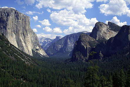
The iconic view down the valley on the drive in from the west.
Vernal Falls
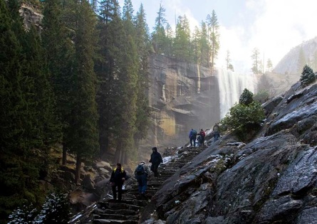
The wet stone stairway of Mist Trail with Vernal Falls in the background.
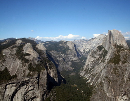
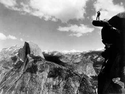
The classic view of the valley from Glacier Point (where the dude in the black and white photo at the top is standing).
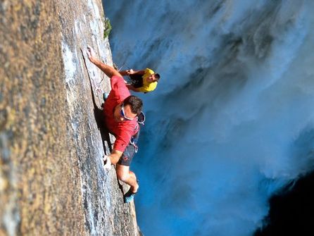
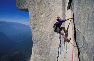
Yosemite is a haven for rock climbers (a bit more on why later).
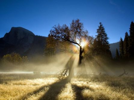
Sunrise in the valley.
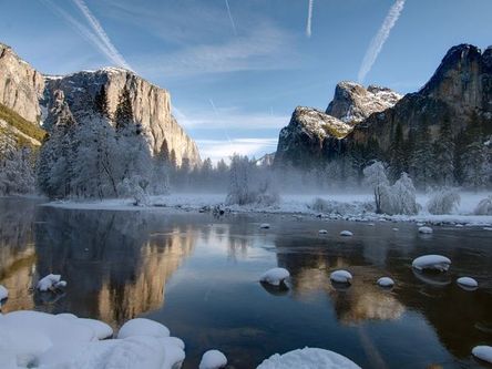
A wintery view of the valley.
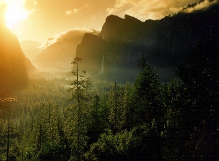
Sunset in Yosemite.
It is truly a magnificent place, and the sheer imposing nature of the huge walls of the valley are difficult to portray in pictures. As John Muir said,
"No temple made with hands can compare with Yosemite. Every rock in its walls seems to glow with life...Awful in stern, immovable majesty..."
"No temple made with hands can compare with Yosemite. Every rock in its walls seems to glow with life...Awful in stern, immovable majesty..."
How Did the Rocks Get There?
Now at this point, I expect that readers will start dropping like flies. Easily accessible natural beauty now takes a back seat to scientific beauty, which requires a little more work to enjoy. With that in mind, I have erred on the side of length rather than brevity with this post, so I will not be offended if you decide to jump ship. For the sufficiently curious, however, I expect it to be worth it.
You may know that geology is the study of the Earth's physical structure and substance. It also looks at how the Earth's history can inform us about what is happening now, and what will happen in the future.
So how did Yosemite come to exist as it does today? How were these huge chunks of granite created? How did they get to where they are now?
These questions open the door to explain one of the fundamental tools of geology: actualism. Actualism is the use of modern observation to understand ancient phenomena. For example, if you want to know how a particular kind of rock was formed, look for where that rock is forming today. A common example is limestone, which is characterized by the mineral calcite. Calcite is a mineral found in the skeletons of marine organisms, notably coral and shellfish. So to find where limestone is forming today, head to the Bahamas or another shallow tropical sea and observe how calcite is being deposited on the sea floor and over time becoming pressurized into limestone. Similarly, this same idea can help us understand what various regions were like during the formation of particular rocks. For instance, since we observe large slabs of limestone in the Colorado Plateau, we can deduce that the area was once covered in a shallow sea. This might seem like a stretch at first glance, but once you look at all the details, there's really not much guesswork to it.
Again, this is the idea of actualism: using modern observation to understand ancient phenomena. In Yosemite, we see that granite dominates the landscape. So we need to understand how granite forms in order to understand how the rocks of Yosemite came to be. Now it makes sense to tell you at this time that we know that granite forms from slowly cooling molten rock. But then where does the molten rock come from? To get a complete picture of how the rocks of Yosemite formed, we'll head to a place you probably wouldn't expect: the Andes Mountains of South America.
When molten rock cools, it begins to form crystals. At the surface (such as after being erupted from a volcano) it is immediately exposed to cold air or water, which doesn't leave much time for minerals to crystalize before it's solid. This results in rocks with very small crystals (like basalt) or no crystals at all (like obsidian). When the molten rock cools underground, however, it cools much more slowly, and there is more time for crystals to form. This results in rocks with larger crystals, like granite. This is a big reason that the granite walls of Yosemite Valley are so attractive to rock climbers—the large crystals of granite give a perfect texture for climbing.
In order to understand the Andes (and in turn, Yosemite), you need a basic understanding of plate tectonics, because at the root of what makes the Andes tick is the collision of two tectonic plates.
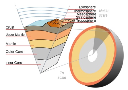
This diagram shows the layers of the Earth. The pie slice at the left is not to scale, but shows the different layers clearly. The semi-sphere at the right shows the layers at their actual scale.
I won't assume that everyone is familiar with plate tectonics, so here is a brief explanation. The Earth is not just a big hunk of solid rock. Only the very outer layer, called the crust, is solid rock. Beneath the crust, about 3-6 miles underground, the mantle begins. The mantle is composed of rock that is extremely hot, and sometimes liquid (you can think of this as magma, or underground lava). It is fluid enough that it can flow very slowly over time. The closer to the center of the Earth you get, the hotter this molten rock becomes until you reach the Earth's core, which is composed of liquid metals, and at the very center solid metals (at least this is the notion most commonly accepted, since we've obviously never been there).

This diagram shows all the different plates of the Earth's crust.
Now back to the crust. The crust is composed of different sections, called plates. These plates are separate from one another, and you can picture them “floating” on top of the mantle. As heat flows through the mantle, the rock in the mantle slowly flows in currents called convection cells. This movement of the mantle causes the plates on top of the mantle to also move. Think of a boat sitting in a flowing river. It wants to move in the direction of the water under it. The same goes for the plates on top of the mantle. The mantle flows in different directions at different locations, however, which in turn makes the plates want to move in different directions. This causes the plates to collide with one another along faults, which are the areas where different plates touch. As you probably know, when plates collide along faults, it results in an earthquake.
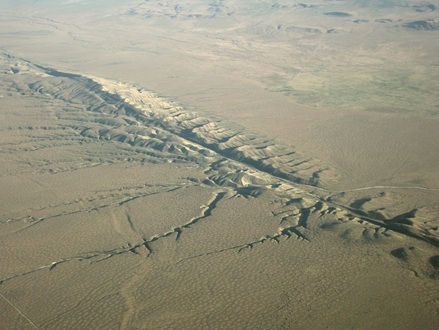
Every Californian's least favorite fault, the San Andreas.
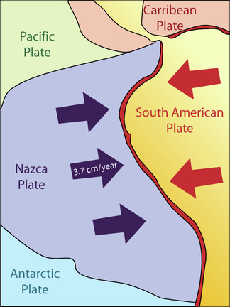
The Nazca plate off the coast of South America is moving eastward while the South American plate is moving westward. How does that work?
So those are the basics of plate tectonics, which is a crucial building block in understanding the origin of the rocks in Yosemite. To see why, let's look back at the Andes. Like I mentioned before, there is a plate just off the west coast of South America called the Nazca plate, and it is moving eastward into the South American plate, which is moving westward. Since the Nazca plate is an oceanic plate, it is denser than the South American plate (essentially meaning that the Nazca plate is heavier). This is causing it to subduct.
Dang it Landon, if you throw me another piece of jargon I'm gonna to smash my computer! Would you get to the point already?!?!
Stay with me.
Like I said, since the Nazca plate is heavier, it subducts. This means it's moving under the South American plate. It's a lot like this:
Dang it Landon, if you throw me another piece of jargon I'm gonna to smash my computer! Would you get to the point already?!?!
Stay with me.
Like I said, since the Nazca plate is heavier, it subducts. This means it's moving under the South American plate. It's a lot like this:
Now, this movement isn't exactly constant like the video portrays. It happens slowly over thousands of years, with each movement of perhaps 1-5 meters resulting in an earthquake of some magnitude.
Here's the important thing. The Nazca plate continues to move downward at an angle. As it goes down, the pressure from the weight of all the rock above increases. At a certain depth, the pressure gets so great that it causes the temperature to rise. Once the temperature increases sufficiently (at a depth a few kilometers beneath the surface), the rock actually begins to melt at the point where the two plates continue to scrape together. Once the rock is melted into liquid form (magma), it begins to rise because it is lighter than the surrounding rock. This causes an upward rising stream of magma to slowly ascend from the point of melting.
Here's the important thing. The Nazca plate continues to move downward at an angle. As it goes down, the pressure from the weight of all the rock above increases. At a certain depth, the pressure gets so great that it causes the temperature to rise. Once the temperature increases sufficiently (at a depth a few kilometers beneath the surface), the rock actually begins to melt at the point where the two plates continue to scrape together. Once the rock is melted into liquid form (magma), it begins to rise because it is lighter than the surrounding rock. This causes an upward rising stream of magma to slowly ascend from the point of melting.

At some point, the magma temporarily halts its ascent and gathers in a huge underground pool of magma, still about a kilometer beneath the surface. This huge bubble of underground magma is called a pluton. As magma accumulates and pressure increases, magma begins to rise from the pluton in small streams, usually flowing along cracks in the overlying rock. Over time, streams of magma continue to rise, and some will eventually rise all the way to the surface to form volcanoes. It should be noted that this is not how all volcanoes form, but is just one way.
You can see how this process works back in that video above. Look off to the right side underground.
You can see how this process works back in that video above. Look off to the right side underground.
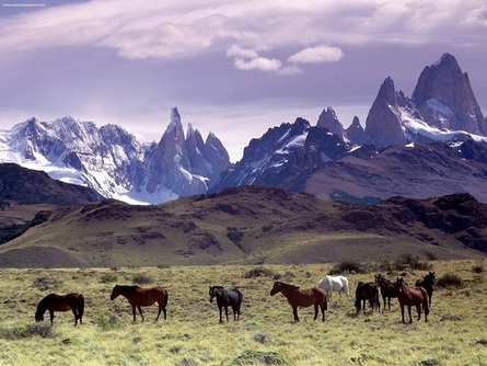
The Patagonian Andes.
As a result, we see a string of volcanoes along the Andes Mountains, but this is not important for our discussion of Yosemite. Remember those plutons though? Those big underground bubbles of magma. That's what we're concerned with for Yosemite.
During the Mesozoic era, about 150 million years ago, the west coast of North America was in a very similar situation to the modern day coast of South America. A tectonic plate called the Farallon plate was subducting under the North American plate, just like the Nazca plate is currently subducting under the South American plate. This Farallon plate's subduction is also believed to have been responsible for the uplift of the Rocky Mountains later on, and possibly the extension of the west side of North America after that (the distance from Reno to Salt Lake City is thought to have doubled over the last 16 million years). We can still see the remnants of the Farallon plate in the small Juan de Fuca plate off the Pacific Northwest and the Cocos plate off the coast of Central America. Other than that, it has almost completely subducted under the North American plate.
But the important thing is that during the Mesozoic, there was magma production under the area of the Sierra Nevada range. We can assume that the ancient Sierra Nevada was very much like the modern Andes in size and scope, but that doesn't have a whole lot to do with the modern day Sierra Nevada.
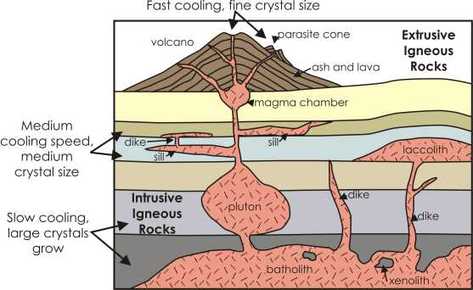
This diagram shows different kinds/parts of magma flow from underground. At the very bottom, you'll see the huge formation of magma called a batholith. That's what we'll be looking at later.
Think back to those plutons I mentioned earlier (the big underground bubbles of magma). There were lots of those under the ancient Sierra Nevada. So many, in fact, that many joined together to where there was an almost continuous string of plutons under the west coast of North America. Eventually, the Farallon plate's subduction changed in nature such that it was no longer producing enough magma to replenish the plutons, and the plutons began to slowly solidify. By the extinction of the dinosaurs 65 million years ago, the plutons had pretty much solidified into huge underground hunks of granite. This ran up and down the west coast, and comprised a huge formation of underground rock called the Sierran Batholith. Some of you will probably see where this is going by now.
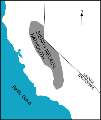
This map shows roughly the area of the underground Sierran Batholith.
During this entire process, the overlying mountains were being eroded away. Additionally, the huge hunks of granite were somewhat less dense than the surrounding rock, so the granite began to slowly rise, almost buoyantly. Between the erosion of the ground above the batholith and the buoyant ascent of the batholith itself, much of the granite eventually reached the surface, being just barely exposed.
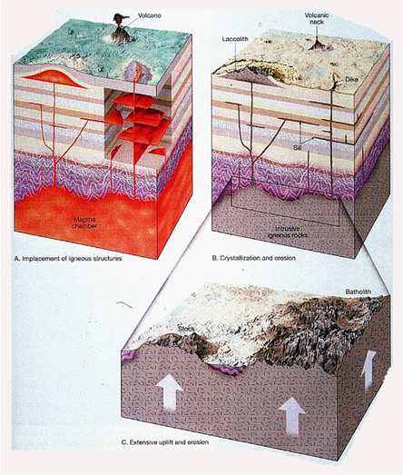
This image shows the process of a pluton's uplift to the surface. At the top left, it shows the pluton's active magma form. By the top right, it has solidified into solid rock. At the bottom, the overlying rock has been largely eroded away, and the underground pluton has 'buoyantly' risen to the surface, and has been somewhat eroded by surface erosion.
This process of uplift was greatly accelerated about 16 million years ago. Around that time was when the continent began to expand from the inside (which I mentioned earlier). This was due to other tectonic forces most likely having to do with the Farallon plate, but that's really all you need to know. What is important is that increased tectonic force was applied to the Sierra Nevada region, and faults began to form on the east side of the granite batholiths that began to slowly push the huge granite batholith upward, one earthquake at a time. By the time the most recent ice ages hit about 2 million years ago, the Sierra Nevada had once again become a substantial mountain range due to the uplift of the Sierran Batholith due to faulting on its east side. By this time, Yosemite was largely on its way to looking how it does today.
The Final Landscaping
So by this time, the stage was set for Yosemite, but it was still sort of a “blank canvas”. Over the past few million years, there have been a few of important geological phenomena that have brought it to its present condition.
So by this time, the stage was set for Yosemite, but it was still sort of a “blank canvas”. Over the past few million years, there have been a few of important geological phenomena that have brought it to its present condition.
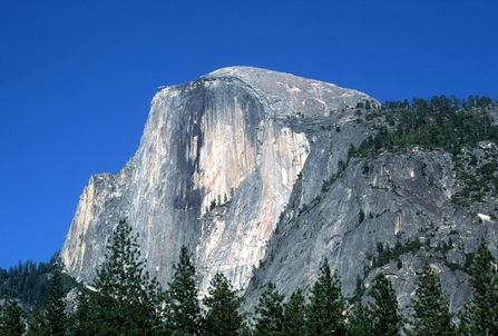
The face of half dome came to be because of natural cracks (or joints) that formed in the rock. One rockfall at a time, rock has fallen away from the face until reaching its present iconic shape.
The first important phenomenon is called vertical fracturing, also called jointing. This refers to the natural formation of cracks in the huge mountains of granite. Specifically, the huge vertical cliffs like El Capitan are a result of these cracks forming at vertical angles. Over time, the cracks are intruded by water and ice, which expands the cracks even more, until finally gravity takes over and causes a huge slab of rock to fall off, leaving a new vertical cliff in its place. These can be truly massive rock falls with really significant damage left in their wake. For instance, the 1996 rockfall in the Happy Isles area of the park caused the flattening of over 1000 trees—just from the air blast generated by the falling rock.
These kinds of rockfalls were probably what gave the valley it's initial shape, which was later altered by other erosive forces, like glaciers. Here's a great video produced by the park on Rockfalls if you're interested:
These kinds of rockfalls were probably what gave the valley it's initial shape, which was later altered by other erosive forces, like glaciers. Here's a great video produced by the park on Rockfalls if you're interested:
The other important erosive force in Yosemite's history is glaciation—the movement of glaciers through the park during the most recent ice ages. Until about 15,000 years ago, glaciers ran through Yosemite and are responsible for a number of characteristics of the valley. First, the glacier bulldozed away any loose rocks on the valley floor, deepening the valley and clearing ground. Second, the glaciers carved the walls of the valley, smoothing the faces of the cliffs and rounding out the shape of the valley. These are really the two main things that glaciation did for the park.
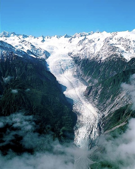
This is the Fox and Franz Josef Glacier in New Zealand. During recent ice ages, glaciers like this one made their way through Yosemite Valley, carving smooth the granite walls to their present shape.
I could talk about just a few other things, but I would imagine most people are ready to get off the ride by this point. So in summary, Yosemite was created by the formation of a granitic batholith due to the hardening of plutonic magma that was brought up from the subduction zone of the Farallon plate. The batholith was then uplifted due to buoyancy (technically, isostatic uplift) and erosion of overlying rock, followed by faulting along the eastern side which uplifted the modern Sierra Nevada. The landscape of the park was finally formed by the erosive processes of jointing and glaciation. And that's about all I have to say.
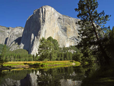
The great El Capitan.
Actually, there's one more thing. At the risk of preventing the creation from speaking for itself, I would like to express my humblest awe at the methods used by God to create these beautiful places. Sure, He could've poofed it into existence, but I guess that would have been too easy. After all, you and I might have been able to have that idea. But I'm pretty sure I could not have engineered a universe that would provide for such a creative process as this one. I'm absolutely awestruck.
And that's just Yosemite.
And that's just Yosemite.


 RSS Feed
